

Structure of aquifers. Traditional and modern methods of exploration work. Choosing a method for searching for water depending on the consumer’s goals. Areas where wells cannot be built.
Where to look for water for a well

The search for water involves finding special formations underground, consisting of two layers of clay and sand between them, which retain moisture. The loose layer can reach a depth of tens of meters and occupy huge areas. The greatest amount of moisture is not found in horizontal layers, but in their fractures and bends. In such places lakes with a large supply of liquid are formed.
Consumers try to find aquifers at a depth of more than 10-15 m. At this distance from the surface there is liquid for irrigation, washing and other needs. In some cases they even drink it.
High-quality water for cooking, enriched with minerals and salts, lies deeper than 30 m. It is necessary to take into account that the law allows the construction of a well with a depth of no more than 20 m. If the water layer is lower, make a project and obtain permission from regional services and the architect of local authorities . Therefore, in your area, it is recommended to search closer to the surface, where water is easier to find and can be obtained without certificates.
Underground layers that follow the terrain are considered successful for wells. Rain streams flow from the hills to the lowlands, from where they rise, already purified, to the level of the aquifer.
- Closer than 30 m from toilets, manure heaps, barns with animals and other similar places.
- Closer than 5 m from the foundation of the building.
- Closer than 300 m from settling tanks and chemical plants.
- Closer than 100 m from industrial waste dumps.
- Near neighboring areas where runoff may enter your well.
- In the lowlands of the slopes of beams, ravines, as well as in the lowest part of the site. It is allowed to dig a mine anywhere on a slope if its angle does not exceed 3 degrees. In other cases, the source should be at the very top of the plot. This arrangement will help to avoid flooding of the well after rain or melting snow and the entry into the mines of substances that can harm humans. If the aquifer is located in such a place, you will have to build a drainage system.
- Do not look for water where the well will interfere with access to the house, driveway, planting a garden, etc.
- Near trees with a strong root system.
- Near power lines.
- In the thickets of bushes and trees. To prevent fruits and leaves from creating problems in the operation of the well, they need to be cut down within a radius of 5-10 meters, which not everyone will like.
- You should also not look for water in the basement of the house. There will be problems with pumping out technical fluid and installing a submersible pump, which requires high ceilings.
Water search techniques
The process of searching for liquid can be called an art, which in the old days was possessed only by true masters of this matter. Currently, modern technologies and special mechanical means are used to search for water in a well site, which make it possible to solve the problem without resorting to geological exploration. Let's consider the most popular methods that allow us to determine the location of aquifers with high probability.
Exploration drilling

Refers to the most reliable methods of search work. Test wells must be drilled in cases where the owner needs drinking water, i.e. it is planned to dig or drill a very deep shaft. Experienced drillers never choose places to drill and offer to build a well where it is convenient for the owner. Thus, they confirm that water is everywhere, but the well may be very deep.
To work, you will need a garden drill with a special handle that can be extended. The optimal diameter of the working tool is 30 cm.
The presence of water is determined after 2-3 m, when wet sand appears. Every 20-30 cm it is recommended to remove the drill and clean it. Drill several wells on the site. To build a mine, choose one of them, which will have the maximum debit.
If you change your mind about building a well shaft, install a casing pipe, a filter and a pump in the well, and you can start pumping water.
Inspecting the source from neighbors

Having a neighbor's well means you can dig one too. Your friends may have invited geologists to survey the site before construction, and these results will help you choose a location.
When studying an existing spring, find out such characteristics as:
- Well depth.
- Height of the water column.
- Level constancy. If it changes periodically, you need to dig deeper.
- Barrel design and type. Build your well taking into account the experience of performing work in the given area.
Dowsing for finding water

Dowsing has long been used to find water for a well. This method is based on the theory that underground liquid has magnetic properties, just like the human body.
For these purposes, find a willow rod in the shape of the letter “V” and dry it. The separated branches should be located at an angle of 150 degrees. The flyer is also carved from hazel, viburnum and cherry. Using this frame, you can determine the boundary between the structures of different rocks, which indicates the close occurrence of aquifers.
To search, grab the branches with your hands, point the trunk to the horizon and slowly walk around the area. Conduct reconnaissance in the morning from 6.00 to 7.00, in the afternoon from 16.00 to 17.00 and in the evening from 20.00 to 21.00. Where liquid accumulates, the barrel will tilt. However, the branches can sense perchal water, which cannot be drunk, so after dowsing it is recommended to dig a reconnaissance well and do an analysis of the liquid.
Modern craftsmen know how to find water in a well site using a frame made of aluminum wire. You need to proceed as follows:
- Cut 2 pieces of wire 400 mm long.
- Bend 100 mm of each piece exactly at a right angle.
- Pick 2 elderberry branches, remove the core and place the short side of the wire inside.
- Take an elderberry branch with wires in each hand. Press your elbows to your body. The wires should be like an extension of the hands.
- Holding them lightly, without effort, walk first from north to south and then from east to west. If the rods turn in one direction, it means there is an aquifer there.
- Above the watercourse, the frames will begin to move and intersect; leave a mark on the ground in this place. After passing the fault, the elements will turn in opposite directions. Walk over the mark again, but in a perpendicular direction. If the wires cross again, there is a high probability that there is an aquifer underground.
- Movement of the vine does not necessarily indicate the presence of water in a given location. There may be a junction of different soils underground, or a large diameter pipe may be laid in this place. Many errors occur near populated areas where there are numerous underground communications.
- The frame does not respond to a large aquifer evenly distributed over the area.
- The presence of water in a given location must be confirmed by other dowsers. If their findings are contradictory, digging a well is not recommended.
- The reliability of the method is only 50%.
Barometric method

It is known that a reading of 0.1 mmHg corresponds to a height difference of 1 m, so a barometer is sometimes used to search for water.
To do this, go to a nearby pond and record its readings. Then record the readings of the device in the place of interest to you. Based on their difference, determine how deep the water lies. For example, if near the river it is 545.5 mm, and in the area it is 545.1 mm, then a difference of 0.4 mm indicates that the liquid is at a depth of 4 m.
This method allows you to find water with an accuracy of 80-85%.
Use of desiccant

The method is based on the property of some substances to actively absorb moisture. For these purposes, you will need silica gel in granules - a bulk substance that is used to reduce moisture levels in enclosed spaces or containers. You also need a simple, thoroughly dried clay pot.
Perform the following operations:
- Dry the indicator in the oven.
- Pour 1 liter of bulk mixture into the pot.
- Weigh the container and record the result.
- Wrap it in thick cloth and bury it in the ground in the place of interest to you.
- Dig it up in a day and weigh the pot again.
- Determine how much the mass of the container has increased.
- Repeat the procedure on another area.
- Compare changes in indicator mass at different locations. Where the mass of silica gel has increased more, the water is located closer to the surface.
Instead of silica gel, pour dry salt or crushed red brick.
To find aquifers, you can use an empty clay pot. Dry it and place it upside down. After a day, inspect the interior of the container. Heavy fogging is a sign of nearby water.
Landscape exploration

You can find a place where water is close to the surface using obvious natural signs. However, they signal high water, which is not always suitable for cooking.
Pay attention to the following points:
- At higher elevations, aquifers are located very deep.
- Don't look for veins near natural lakes and quarries.
- There will also be no positive results near large plantings of acacias and beech.
- The desired areas can be identified in the summer at dawn by the fog that gathers over the place of interest to us. The denser the atmospheric phenomenon, the less you have to dig.
- Sedge, wash away, coltsfoot, and alder always grow above aquifers.
- Birch trees are a good sign that liquid is nearby. On wet ground they look unsightly - short, twisted, with a knotty trunk.
- If the trunks of alder, willow and birch are strongly inclined in one direction, it means that there is moisture close to the surface.
- The presence of thickets of nettle, sorrel, and hemlock in the area indicates wet soil.
- A pine or spruce grove says the opposite - the layer we are interested in lies very far from the surface.
- Some plants determine how deep the water is, but they must be wild and grow in large groups. Pay attention to thickets of blackberries, bird cherry, lingonberries and buckthorn.
Observation of animals and insects

Villagers know how to find water for a well by the behavior of animals and insects:
- Small field rodents do not build nests in places where they can be flooded. In such cases, they settle on high ground or in trees.
- In extreme heat, the horse begins to beat the ground with its hoof above the place where the humidity level is maximum.
- In summer, dogs bury themselves in slightly wet soil.
- A hen will not make a nest on the ground with high humidity.
- The goose, on the contrary, builds a nest above the source.
- Midges accumulate in large numbers where there is evaporation.
All methods for finding water with your own hands can only approximately indicate its location, so you should not rely too much on them. Before digging a well, it is recommended to drill an exploration shaft and do an analysis of the fluid. Only specialists can absolutely accurately indicate where the aquifer is located, but for this you will have to pay a lot of money.
Owners of country houses and plots, in order to establish comfortable living, must ensure uninterrupted water supply. The best option is to equip a well. Therefore, many people need to know how to find water on the site for a well with their own hands.
To dig a well at your dacha, you need to find a suitable place where the water vein passes.
Aquifers and location in the ground
Finding water underground is not easy, because it is located between layers of soil, through which it cannot seep due to the moisture-resistant composition. The basis of such layers is clay and solid sediments. Layers of clay alternate with sand, gravel and pebbles. These layers contain pure water. Those who develop a source of drinking water need to dig down to such aquifers.
It must be taken into account that a layer containing water does not have the same parameters along its entire length. Somewhere the layer becomes thinner, somewhere it expands and goes to greater depths. The waterproof layers are also not the same: the arrangement can be horizontal or curved at different angles. Large volumes of sandy layers saturated with moisture lie in the bends and curvatures of impermeable layers.
The influence of burial depth on water quality
When developing a well, you can stumble upon an aquifer already at a depth of 2-2.5 m from the surface of the earth. This source is called perched water and is not used for water supply to private households. The close location to the ground indicates that the water collected due to melted snow, rain and water from nearby reservoirs. Its quality is low, because there is a risk of sewage and other dirt seeping through.
The high water is unstable. The layer containing high-quality water is located 15 m from the ground surface. Sand is a natural filter that purifies water from dirt and other dangerous microelements.

Water occurrence diagram.
Observation when searching
You can find a watercourse in your dacha using your own powers of observation. It is enough to pay attention to the behavior of animals, some natural phenomena and plants.
Summer fogs
Soil saturated with underground moisture will emit evaporation. Early in the morning or in the evening at the end of a hot day, you need to observe the area where the location for the well has been selected. If fog hovers over the ground, there is water. Optimally, if the fog gathers in clouds in one place or rises upward in a column, this indicates that there is a lot of water and the layers are located close to the surface. Waterproof layers copy the terrain. Therefore, there will be moisture in ravines and depressions that are surrounded by hills. On flat terrain and slopes its presence is questionable.
Animal behavior
In the heat, in order to cool down, dogs dig small holes and lie down there. Pets sense cool, and therefore damp, places. The close location of moisture-containing layers provides such temperature characteristics of the soil. Poultry is also worth watching. Chickens do not lay eggs where the humidity is high. Geese, on the contrary, choose places where they intersect to build their nests.
Various midges sense places with high soil moisture. The insects cluster together and swarm over damp areas in the afternoon. Field mice, on the contrary, do not like moisture. Rodents will build nests only in dry places, sometimes even climbing trees or buildings that rise above the ground.

You can determine the location of the water by your pet’s choice of resting place.
Types of growing plants
Some plants can tell you whether there are underground reservoirs on the site. A birch tree growing above underground springs will be small in height, with a crooked trunk and growths on it. The herbaceous plant chickweed and river gravel also indicate a watercourse in the area where the plants grow. Indicators of the presence of groundwater are lingonberries, blackberries and bird cherry.
A pine with a long root in the form of a rod, on the contrary, indicates the location of water sources at great depths.
Help from friends and neighbors
If there are houses or summer cottages nearby, you can talk to your neighbors. Perhaps they have already established a water supply and will be able to suggest where a good place to place a well is. It is also recommended to learn about the composition and quality of water, about fluctuations in water levels.
Practical Search Techniques
After the observation stage, you can begin a practical search using standard and traditional methods.
Using glass containers

Finding water using cans.
Dry open glass jars are placed upside down in the area to search for a watercourse. After 7-8 hours, the banks are inspected. Where the inner surface of the container becomes most moist and the accumulation of condensation is greatest, it is recommended to dig a well.
Application of hygroscopic material
You can find water using hygroscopic materials. These include salt, red brick, silica gel. For this method, you need to prepare an unpainted clay pot and choose a hot period for research so that the soil is dry. Pre-dried salt, brick chips or silica gel should be poured into a pot, the container with the contents should be weighed, wrapped in gauze or agrofibre and buried in the soil to a depth of 50 cm. After a day, the pot is dug up and weighed again, if the difference in weight is significant and moisture is close.
Almost scientific methods of dowsing
It is difficult to classify such methods as scientific, but there is no doubt about their effectiveness.
Aluminum electrodes and wire
Using aluminum frames is a popular method. Aluminum picks up magnetic vibrations in the area that are affected by water.
To find a water vein, you need to prepare:
- 2 pieces of aluminum wire 40-45 cm long;
- 2 fragments of a viburnum or elderberry trunk 10-12 cm long.
A piece of wire 10-12 cm long on both sections must be bent at an angle of 90° for handles. Cut the wooden blanks to the length of the handles and remove the core. Insert the wire into the handles so that nothing interferes with the smooth rotation.
To search, you need to walk around the area with frames in your hands, press your elbows to your body, and do not clench your fists too much. During movement, the ends of the frame should be moved in opposite directions. If there is a water-bearing vein underground on the left or right, both ends of the frame will turn in the right direction. If the watercourse is a few meters ahead, the ends of the wire will close together.
To ensure that the chosen location is correct, it is recommended to walk around the area again, but follow a different route.
Willow vine at the heart of the search
Willow naturally senses water and reaches out to it with its branches. It is not difficult to search for the source yourself using a vine. To do this, you need to find a willow branch with 2 ends coming out of one trunk and dry it. Then you need to take the edges of the vine in each hand and spread them apart so that the angle between them is approximately 150°, the branch should be directed slightly upward.
With such a device you need to go around the area. Where there is a watercourse, the willow branch will fall closer to the ground without difficulty or effort.
For more accurate indicators, it is recommended to walk around the territory:
- from 6 to 7 am;
- afternoon from 16:00 to 17:00;
- in the evening from 20:00 to 21:00;
- at night from 12 to 1 o'clock.
Finding water by drilling
Drilling is a more expensive method of finding an aquifer; the cost of developing some wells is equal to the cost of equipping a well with rings. Therefore, drilling with industrial equipment is rarely used in private areas. This type of development is justified in the case of well equipment for large industrial enterprises where water is used in large volumes.
For a suburban area, a hand-type garden drill is used, the diameter of which is 30 cm. With the help of such a drill, test holes are made with a depth of 5 to 10 m. During the drilling process, after introducing the tool into the soil, every 15-20 cm you need to remove the soil with an auger and inspect it. This is done to prevent breakdowns and check the soil moisture level, which indicates the proximity of an aquifer.
This search method is effective and affordable, but the result will largely depend on the skills of the driller.
After the watercourse is found, you should not immediately dig a well hole. It is necessary to ensure that the water found meets the standards. It is recommended to send samples to a laboratory for analysis and wait for the experts to respond. If the result is satisfactory, you can end the search.
A well is the simplest hydraulic structure. This is a profitable option for organizing water supply if there is no centralized mains nearby. Minimal construction costs, convenient operation, constant access to water - there are many advantages. But how to find water on site for a well in order to build a productive source? We learned how to solve this problem a long time ago.
The proven “old-fashioned methods” are still successfully used, and in recent decades even more reliable methods and even special devices for searching for water have appeared. Each site owner can choose an acceptable method or use several. This will help you determine with absolute accuracy where it is best to dig a well.
Framework for finding underground water
Classification and properties of aquifers
There may be 2-3 aquifers on the site. They are loose rocks that bind and retain moisture that seeps from the surface during rains, floods, and snow melting. Aquifers are located on impermeable rocks and can have different sources of recharge. The deeper the horizon lies, the cleaner and better quality the water is.
There are several types of groundwater:
- Soil. This is the topmost layer (usually 4-6 m). Atmospheric moisture accumulates in it. Sources of power for the horizon are precipitation, floods, and river floods.
- Ground. The horizon lies at the depth of the first layer of waterproof rock - 9-18 m, suitable for the construction of a drinking well.
- Interlayer. Wells are drilled into this horizon. The depth ranges from 20 to 40-50 m.
- Artesian. The aquifer is the cleanest and most abundant, but it is not suitable for building a well, because... its depth can reach 40-200 m.
Information about the depth of aquifers is necessary to determine water quality. Shallow layers are often contaminated with pesticides, human waste products, and pathogenic bacteria. Such water is used only for technical purposes. For drinking and cooking, it must be carefully filtered and boiled.
Sometimes the first aquifer lies very shallow - 2-2.5 m from the surface. If the future well is intended for watering the garden, then this is an excellent option, but you cannot drink from it. Even for domestic and economic needs, it is advisable to pass water from such a source through a coarse filter.

Aquifer location diagram
How to find a place for a well using folk methods
How to find a place to dig a well? The most reliable way is to contact specialists who will find a suitable aquifer for relatively little money. This is desirable, but not at all necessary, because you can do it yourself.
There are several folk signs by which you can find an aquifer that lies close to the surface. Some plant species indicate the proximity of moisture. They also often use a vine or special frames. You can make these devices yourself.

Choosing a location for a well using a vine
How to determine the depth of a vein
Places where moisture comes very close to the surface can be identified by simple signs:
- Fog. If there is an area over which fog appears, then this is a sure sign of high humidity. It is worth observing either in the evening before sunset or early in the morning. It is best to inspect the area at dawn, when the foggy haze is most clearly visible. If the fog is thick, it means the aquifer is not deep at all.
- Midge. Small midges swarm where they sense moisture. If it is noticed that they prefer a certain place on the site, it is worth digging a well here.
- Herbs. Moisture-loving plants grow only where they can get enough water from the soil. It is worth paying attention to whether there are nettles, coltsfoot, and wild sorrel on the site.
- Trees. Some types of trees can also be reliable indicators: alder, beech, willow, birch. But apple and cherry trees, on the contrary, do not do well in places where aquifers are close.

Scheme: how to find water for a well by plants
Animals are helpers in the search for underground water
If field mice live on the site, the location of their nests can help with finding a place for a well. For example, if voles settle directly on the ground, it means that the aquifers are deep in the soil. These animals avoid high humidity. If they build nests on the lower branches of trees and bushes, it means the moisture is close to the surface.
Poultry can also indicate where to dig a well. Thus, chickens never lay eggs in damp places, but geese specifically look for the wettest areas to build their nests. If a domestic goose lays eggs in the same place, this is a sure signal that at least one aquifer lies nearby. Most often, geese look for intersections of veins.
In the summer heat, animals try to find the coolest areas. If the horse starts pawing and the dog digs a hole, this is probably the wettest place on the property. If animals dig small depressions in the soil and lie down in them, then a well can be built here. The water in it will be of poor quality, but it will be suitable for watering the garden and technical needs.

Dogs look for cool places
Dowsing method: vine and aluminum frames
The vine or frame will tell you how to choose a place for a well on your property. Dowsing is considered one of the oldest methods of searching for aquifers. It cannot be called 100% reliable, but in many cases this method turns out to be effective. For dowsing, either tree branches or aluminum frames are used.
Production and use of dowsing frames
How to make frames for finding water? They are easy to make with your own hands. To do this, you will need two pieces of aluminum wire of the same length (about 40 cm each) and a tube cut from elderberry or other suitable material.
Work order:
- The pieces of wire are bent at right angles so that one side is 15 and the other 25 cm.
- The short ends insert a tube cut from a tree or bush branch. The ideal option is elderberry, but variations are possible. A metal tube will also work.
- The wire does not need to be secured; it should rotate freely in the tube, but not fall out of it.
Using this device is very simple. The frames are taken in both hands and slowly passed across the area. If both frames turn in one direction, then you should turn there. In a place where the aquifer is close to the surface, the frames will come together. As soon as the vein is passed, they will again move apart. This way you can determine the area suitable for constructing a well.
Video: how to make a frame for searching for water
How to choose a place for a well: modern methods
A variety of methods are used to search for water, from digging salt into the ground to using instruments. They make it possible to determine not only the presence of an aquifer, but sometimes even the depth at which it may lie.
Option #1: glassware
Soil moisture can be determined using glassware. A regular three-liter jar will do. It is placed with its neck on the ground in a place where the presence of a nearby vein is suspected, and left overnight. If condensation appears on the glass in the morning, you can dig a well.
The method will be effective only if there has been no rain for several days before and the ground has dried well. It can be used during periods of extreme heat and drought. Based on the amount of condensate, assumptions are made about the depth of the water.

Option #2: moisture-absorbing materials
You can use substances that absorb moisture well. The most common choices are rock salt, building red brick or silica gel. Before use, the brick is crushed to a crumb state. Silica gel is further dried in the oven. The total volume of the desiccant should be about two liters. It is poured into an open clay pot.
The vessel and its contents are weighed on high-precision scales, after which they are wrapped in several layers of gauze and buried in the soil to a depth of about 0.5 m. It must remain underground for at least a day. After the required period has passed, the pot is carefully dug up, the gauze is removed and weighed again.
If the weight of the vessel is different, it means that the moisture-absorbing materials have absorbed moisture from the soil. The greater the difference between the indicators, the closer to the surface the spring vein is located. It is believed that the effectiveness of this method reaches 60-65%.

Option #3: barometer readings
If there is an open body of water near the site, then a barometer can be used to determine the depth of underground layers. With its help, they determine the pressure on the shore of a reservoir, and then move to a place where they suspect the presence of a nearby aquifer, and take measurements again.
Each 0.1 mm of mercury column indicates 1 m of formation depth. For example, if the first measurement gave 545.5 mm, and the second 545.1 mm, then the spring vein is located approximately 4 m from the surface of the earth. Searching for water using instruments gives better results than the “old-fashioned” methods.

Schematic diagram of the aneroid barometer
Option #4: a device for finding groundwater
There are special devices for searching for water underground. The domestically produced “Pulse” device, which measures the electric field created by groundwater, has proven itself well. Using “Pulse” you can even determine the potential productivity of a future source.
The water search device is easy to use. Its electrodes are buried 10 cm into the ground in the place where the presence of a vein is suspected. If the readings on the device change, it means there is water nearby. The higher the indicators, the more powerful the aquifer.

The owners themselves determine how to find a place for a well on their property, choosing the most affordable method. All methods have their drawbacks, and they are not always reliable. If you want to ensure that the location for the well is chosen correctly, carry out exploratory drilling with a regular garden drill. Better yet, contact a specialist. They will help you choose the ideal location for the well.
(20
ratings, average: 4,20
out of 5)
 Water is the basis of the life force of humans, animals, plants, along with food and air. Every day, humanity uses tons of this invaluable substance for various needs. Today it is very important to find sources of clean water.
The best and most reliable source is a well. It will help solve the problem of water supply to your home and site. Wells are especially in demand among owners of private houses. However, every site owner asks a number of questions before starting construction of a well. How to find a suitable place for a well on a site? What should be the depth of the well? How to understand where to dig a well on a site?
Today the problem of finding water for a well is solved! There are many ways by which it is very easy to determine exactly where groundwater flows on a site. It is worth noting that any owner can cope with this matter, but an error in the search can lead to financial losses - the well will not provide water, and you will have to dig a new one. It may be worth considering inviting a specialist to find the right location. However, this can be quite costly, so the preferred option for many is finding water yourself. How to find a spring for a well?
So, as for finding an aquifer vein. Only when you find it can you be sure that the location for the source was found correctly. But the question arises: how to determine where to dig a well? The answer is very simple. Anyone who is going to build a well must know at what depth the spring should be located.
Well spring depth
 In search of the location of water for a future source , you can discover the lake, which is close to the surface. And the depth of such a lake can vary from 2.5 meters. The water in it is called perched water. And such a source is not suitable for a well, because it accumulates sediment, melting snow, dirt and harmful substances that cause devastating harm to human health.
Still, for a good and high-quality well you need drinking water from lakes located at least 15 m deep into the ground. It is important to note that groundwater can be easily found without significant costs.
There are several methods for finding water:
- Observing the behavior of animals, insects and plants
- Using desiccant
- Condensate detection
- With plant forks or aluminum frame
- Meteorological
- Drilling
Now let's look at each of the methods separately.
Behavior of animals, insects and plants
 For example, you may discover an aquifer, With using traditional methods. Monitoring your horse or dog in dry weather can help you with this. A horse may hit the ground with its hoof in search of moisture. Any dog, trying to escape the heat, digs a hole and lies down in it. Dogs try to find the coolest area. And such a location can only be located next to groundwater sources. These animals have the ability to sense the proximity of underground springs.
And the last helpers in the search for water - ordinary midge. These insects live in places where humidity is high. An interesting fact is that insects gather in one specific area. And this can only mean one thing - the water is very close.
Weather conditions and plants can play an important role in determining a good location for a spring in the country. For example, fog can indicate where in an area there is a higher level of humidity. It is worth noting that the denser the fog, the closer the underground water sources flow. Sedge, birch, and coltsfoot can become your helpers. These plants will tell you the nearby location of underground currents. In searching for water in the area, you will be helped by various types of devices that you can easily build yourself.
Desiccants
In order to look for sources, desiccant can be used. For example, sorbent or ordinary red brick, which usually splits into many small pieces. These parts must then be placed in a pot made of clay and weighed. Next, place it in dry soil to a depth of 0.5 meters. After 24 hours, the pot needs to be dug up and weighed again. Determining the difference when re-weighing makes it possible to establish the close location of underground sources.
Condensation detection
There is another great way to determine the location of an aquifer. And this the simplest glass jars. It is important that the sizes of the cans are identical. At dawn, the device must be stuck into the soil at intervals of 5 meters. After a day, you need to turn the vessels over and look at the condensation. The location of the vessel with the largest amount of condensate is most likely where groundwater flows.
Finding water using a frame
However, in addition to traditional methods, there are many modern and more accurate ones. And people prefer to look for springs using more modern methods, which, for example, include the method of searching for underground water using dowsing, which is implemented in reality using forks made from natural raw materials, an aluminum frame and the like. A very interesting method is to use a willow or vine fork. To try this method, find a twig with two knots. Then cut and dry it, take the ends of the branch in both hands and boldly begin the search process. It is important that the stem points upward. If it begins to sink to the ground, then the most suitable place for the future well has been found.
Another very effective way is to use an aluminum frame.
Frame manufacturing and operation diagram:
- In order to make this device you will need 2 pieces of aluminum wire, approximately 35 centimeters long, on which you need to bend the sections at right angles.
- The bent sections are taken in such a way that the remaining parts are parallel to the soil. If the ends of the wire begin to cross and twist, this means that groundwater sources are located quite close. And this is the place that is most suitable for your well.
Meteorological
And there is also meteorological method, which is one of the most productive. Eighty percent of the time, it accurately points to an underground source. The method is observation. If after a hot day the soil in the area is wet, it means there is underground water there.
Drilling
 We can highlight another of the most accurate methods of searching for water on the site. This exploration drilling. Exploration drilling is one of the most accurate methods, but at the same time one of the most labor-intensive. Using this method, the depth of underground sources can be determined 100 percent. You can also resort to the barometric method, which allows you to accurately determine the depth of groundwater. The effectiveness of this method is 85 percent.
And finally, to make your search as easy as possible, you can use geological and groundwater maps. Of course, such maps will not point you to the correct location for the spring, partly because environmental conditions are constantly changing, but they can only indicate the approximate location of the spring, its depth and the amount of water in it. The accuracy of such maps is approximately 15-30 percent.
A combination of several methods can significantly increase the chances of quickly finding a suitable location. Is it justified that in order to accurately search for the location of groundwater, it would be best to invite a professional specialist in the field who knows exactly how to find a spring on the site? Of course, you can rely on your experience and luck, or you can entrust the search to a professional, the choice is up to you.
A well at your dacha is sometimes the only source of drinking water and you want the quality of the water in it to be good. Therefore, already at the stage of searching for water, it is necessary to know at what depths the best aquifers are located. To get to them, you need to explore the entire area and choose the best place. Let's look at how to find water for a well in various ways.
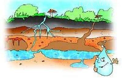
Water is retained in the ground thanks to water-resistant layers that prevent it from flowing either to the surface or deeper. The main component of the layers is clay, which is very resistant to moisture. Sometimes there are also stones. Between the clay layers there is a sand layer that retains clean water. This is the aquifer that must be reached in the process of digging a well.
In some places the sand vein can be thin, in others it can be huge. The largest volumes of water are obtained in places where the waterproof layer breaks, which is not located strictly horizontally, but with height differences and bends. And where the clay makes a curvature, changes the direction of height, peculiar breaks are obtained that are filled with wet sand. These places are so saturated with water that they are called “underground lakes.”
How does water quality depend on depth?
When digging a well, you can stumble upon an aquifer very quickly - already 2-2.5 meters from ground level. It is not advisable to take drinking water from such aquifers. Due to its proximity to the soil surface, rainwater, melting snow, and sewage runoff penetrate into the vein from above, polluting the water and significantly deteriorating its quality. Experts call such surface veins a special term – perched veins. In addition, these layers are quite unstable. If it is hot in the summer and there is no rain, the water from the high-water lakes disappears, which means that it will disappear in the well. So, during the “peak” summer season, summer residents may be left without water, until the fall.
The optimal depth at which to search for water for a well is 15 meters. At this depth there is a line of continental sands that hold very large volumes of water. And the significant thickness of the sand layer contributes to maximum cleaning of the aquifer from all kinds of debris and “chemicals”.
Search for an aquifer using observation methods
To find water, it is not necessary to invite specialists. For many centuries, people in villages managed on their own, using observations of nature and animals.
Fog observations
During the warm season, inspect the area early in the morning or late afternoon. Where groundwater is close, fog forms near the ground. And by its consistency you can determine how deep the aquifer is located. The thicker the fog, the closer the water. Fogs caused by moisture rising from the ground do not stand still, but come out in clouds or spread close to the soil.
Animal behavior in the heat
Field mice will not make nests on the ground if water is close. They will move their homes to tall plants and tree branches.
If the owner has a dog or a horse, then in the summer, when the speck is on, you need to observe their behavior. Thirsty horses begin to look for water in the soil and kick in the place where the humidity level is highest. Dogs try to “bring down” their body temperature a little, so they dig holes in damp places and take refuge in them. Moisture, evaporating, cools the ground, which is why animals tend to lie down at these points.

Dogs sense nearby water and dig holes in these places to escape the heat.
Poultry is also a good indicator. The chicken does not lay eggs where it senses the proximity of water, but the goose specifically chooses places where water-bearing veins intersect.
In the evening, when the heat subsides, you can also watch the midges. They begin to cluster in groups and form “columns” over the wettest parts of the site.
Exploration drilling method
Assortment of indicator plants on the site
Since ancient times, plants have informed humans about the depth of the aquifer. Moisture-loving people will never live in places where the groundwater is very deep. But if coltsfoot, hemlock, sorrel, and nettle are in full swing at the dacha, it means there is enough moisture in the soil.

By looking at the plants growing at the dacha, you can determine at what depth the aquifer runs
Alders, willows and birches grow well in moist soils. If their crown is inclined in one direction, then that is where the aquifer should be looked for. Apple and cherry trees will never grow well in places with close groundwater levels. The fruits will constantly rot and the tree will become sick.
Practical methods for finding water for a well
In addition to observations, you can use various devices for searching. Let's look at how to look for water for a well using objects.
Arranging glass jars
In the morning, place glass jars of equal volume throughout the area, turning them upside down to the ground. The next morning, check which areas have condensation. The larger it is, the closer the aquifer.
Lay out salt or brick
We wait until there is no rain for a couple of days and the soil becomes dry. Take dry salt or red brick crushed into small pieces and pour it into a clay pot (unglazed). We weigh it, record the readings, wrap everything in gauze or spandex and bury it half a meter into the ground. A day later, we take out the pot, remove the material and weigh it again. The greater the difference in mass, the closer the aquifer. By the way, among modern moisture accumulators, silica gel is also suitable.
Indication by aluminum or wicker frames
1 way:
- We take two pieces of aluminum wire 40 cm each and bend them 15 cm at a right angle.
- We insert them into a hollow tube (preferably cut from an elderberry and remove the core).
- We check that the wire rotates freely in the tube.
- We take the tube in both hands and walk around the area. The ends of the wire should be turned left and right. If there is a water-bearing vein under your feet, the wires will converge towards the middle. If water is found to the right or left of a person, the ends of the wires will turn in this direction. As soon as the aquifer has passed, the wire will again turn in different directions.
- Having found the place where the aluminum meets, go again, but perpendicular to the direction in which you moved first. If the place of closure is repeated, dig a well there.
Method 2:
- We cut out a branch from the vine, in which there are two forks on one trunk, going at an angle of 150 degrees to each other.
- We bring it home and dry it.
- We arrive at the dacha, take the ends of the branches in both hands so that the trunk is in the middle and pointed upward.
- We walk around the site. As soon as the trunk leans toward the ground, that’s where you should look for water.

The raised vine trunk will bend towards the ground as soon as it senses nearby water
The vine and aluminum give a signal that there is water in the ground, but it may also be perched water, which is not suitable for a well. Therefore, after identifying places with high humidity, carry out preliminary drilling to understand at what depth the aquifer is located.